

Mata Agung, is a team of aerospace enthusiasts using drones to visual inspect Mount Agung. The enthusiasts are filling a void for public safety as the local authorities have no such technology, only trusting seismographs to monitor the volcano. But they are not the only ones using drones to monitor volcanoes.
Mount Agung volcano in Bali experienced a series of eruptions on November 25th. The series of eruptions were the first sign of activity by Mount Agung in more than 50 years and prompted the highest alert level. In 1963 a major eruption killed about 1,100 people where the VEI (Volcanic Explosivity Index) was 5. The VEI associated with an eruption is dependent on how much volcanic material is thrown out, to what height, and how long the eruption lasts. The scale is logarithmic from VEI 2 and up; and increase of 1 index indicates an eruption that is 10 times as powerful. The scale goes from 1 to 8, where a VEI 8 happens once everyone 50,000+ years. Below is a chart of VEI courtesy of Wikipedia.
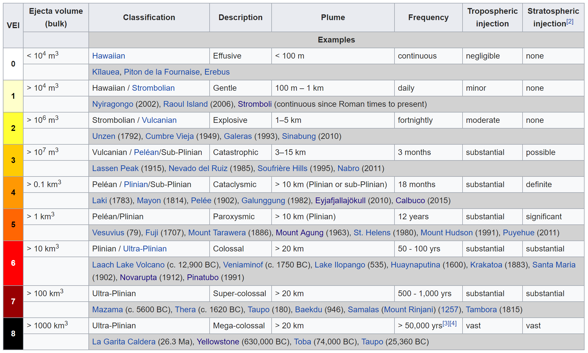
Volcano Explosivity Index (courtesy of Wikipedia)
The behavior of erupting volcanoes ranges from a quiet, steady effusion of lava to highly explosive eruptions which blast several cubic kilometers of volcanic ash and corrosive gasses high into the atmosphere and over a wide area for several days. The explosive activity of some volcanic eruptions are of greatest concern to aviation, mainly because of the great volume of ash and the heights that the ejecta can reach in larger eruptions. An ash cloud from a large volcanic eruption can remain in the atmosphere in dangerous concentrations for many days. Over this time, the ash cloud can travel many thousands of miles with prevailing winds. This becomes an issue for aircraft. Ash clouds pose great danger to aircraft and can lead to engine failure. The fine, abrasive particles erode metal, clog fuel and cooling systems and melt to form glassy deposits. Flight instruments, windows, lights, wings and cabin air supply can also be affected. An eruption can cause billions of dollars in damage, like the Eyjafjallajokull volcano in Iceland in 2009, which caused $9 billion loss to the airline industry. In response, studies are in place to improve the predictability of volcano behavior.

Eyjafjallajokull as seen from space- Courtesy of NASA
Earlier this year, a team of volcanologists and engineers from the Universities of Cambridge and Bristol has collected measurements from directly within volcanic clouds, together with visual and thermal images of inaccessible volcano peaks at Volcán de Fuego in Guatemala. While long-term forecasting of volcanic eruptions is not possible, volcanologists are able to give short-term forecasts based on their own monitoring techniques (e.g. seismic activity, ground deformations). Although primarily used for providing warnings to local communities, this information can be used by communities and emergency services. The video below shows a brief overview of the research involved.
Note: Opinions expressed are those of the author and not of NASA.